NHC: Idalia to likely hit Florida as ‘major hurricane’ Wednesday

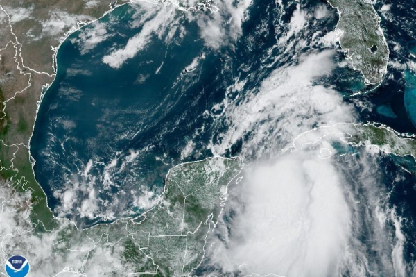
Tropical Storm Idalia was moving north on Monday morning as it was expected to reach hurricane strength before making landfall in western Florida by Wednesday. Photo courtesy NOAA
Tropical Storm Idalia was continuing to strengthen off the coast of Cuba early Monday, with forecasters warning that it could grow into a major hurricane before it makes landfall in Florida on Wednesday.
In its 1 p.m. CDT update, the National Hurricane Center located the storm about 50 miles south-southwest of the western tip of Cuba and 280 miles south-southwest of the Dry Tortugas. The storm was carrying maximum sustained winds of 70 mph and was moving north at 8 mph. Advertisement
A hurricane warning is in effect for Pinar del Rio, Cuba, as well as the Middle of Longboat Key northward to the Ochlockonee River, including Tampa Bay with a hurricane watch issued for Englewood to the Middle of Longboat Key and west of the Ochlockonee River westward to Indian Pass.
Meanwhile, a tropical storm warning was in effect for south of the Middle of Longboat Key to Chokoloskee, Fla., and west of the Ochlockonee River westward to Indian Pass. Advertisement
A tropical storm watch was in effect for the Lower Florida Keys, west of the west end of the Seven Mile Bridge and Sebastian Inlet, Fla., northward to the Altamaha Sound, Ga.
A storm surge warning was issued from Englewood northward to the Ochlockonee River, including Tampa bay, while a storm surge watch has also been enacted from the mouth of the St. Mary’s River to Altamaha Sound, Ga.
Idalia had been moving erratically on Sunday but was practically stationary overnight. The NHC said the system is expected to move north on Monday and be over the extreme southeastern Gulf of Mexico by Monday night.
“Strengthening is forecast, and Idalia is expected to become a hurricane later today,” it said. “Idalia is likely to be near or at major hurricane intensity when it reaches the Gulf coast of Florida.”
The center is warning that the risk of it producing a life-threatening storm surge and hurricane-force winds along portions of the west coast of Florida and the Florida Panhandle as early as Tuesday was increasing, with both storm surge and hurricane watches in effect for portions of both regions.
“Residents in these areas should monitor updates to the forecast and follow any advice given by local officials,” it said. Advertisement
The NHC is warning that the combination of dangerous storm surge and the tide will cause dry areas near the coast to flood.
The Aucilla River could reach as high as 11 feet if the peak surge occurs at the time of high tide, it said, adding that the Chassahowitzka River could hit 9 feet, and the Ochlockonee River, the Anclote River and Tampa Bay could reach 7 feet.
The Middle of Longboat Key may reach hit 5 feet with Englewood, Charlotte Harbor and Indian Pass may hit 4 feet and Chokoloskee and the Florida Keys potentially 2 feet.
Portions of Florida’s west coast, the Florida Panhandle and southern Georgia are forecast to receive between 3 to 6 inches of rain between Tuesday and Wednesday with isolated higher totals of 10 inches.
Water temperatures along the Gulf Coast are in the upper 80s, as measured by the National Oceanic and Atmospheric Administration. These warm temperatures may act as a type of fuel to strengthen the storm ahead of landfall along the coast.
Idalia is gaining strength as Hurricane Franklin approaches the Bahamas and Florida from the southeast. The NHC says Franklin is expected to reach Bermuda by Wednesday. Its path will then curve along the East Coast. Advertisement